Testbed, Partners:
TB-2 – Pyrenees mountain range, France – BRGM (YET, GMP, NOR).
Area:
Region: 76,000 km2
Tarbes: 15 km2, Luchon 295 km2.
Affected population
5,155,000 (Tarbes: 40,500, Luchon: 5,600).
General building stock inventory:
Available (Tarbes, Luchon).
Existing infrastructure:
Hospitals, SEVESO industrial sites, dams, schools, high-speed train line between Perpignan and Figueras.
Key stakeholders:
LFP Perthus; French Ministry of Interior, Prefecture of Pyrenees Orientales and Hautes-Pyrenees, DREAL Occitanie.
Existing Sensor networks:
Strong motion network (operated by BRGM), strong-motion network (operated by Observatoire Midi-Pyrénées OMP), broadband network (operated by Institut Geologic de Catalunya IGC).
TB-setting and seismic hazard:
The Pyrenees are located in the south-west of France at the border with Spain and constitutes one of areas of highest seismic hazard in mainland France. This TB has a regional extent in terms of seismic network coverage and it aims to focus on more localized assets within the Pyrenees mountain range (French-Spanish border).
During TURNkey:
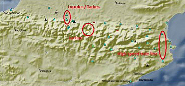
10 TURNkey multisensor units (accelerometers) will be deployed in the area focusing on the towns of Tarbes, Luchon and Lourdes, along with the 45 km-long high-speed train line between Perpignan and Figueras, managed by LFP Perthus, in order to improve coverage for the towns. The instruments will be mounted on structures in order to assess directly the damage evolution of key buildings. Moreover, the high-speed train line, which is currently not monitored by any close-by sensors, will be instrumented at key locations (e.g. viaducts and railway bridges).
Instrumentation

TB-2a – Pyrenees: existing stations connected in real-time (triangles) and planned areas for additional instrumentation (red circles).
