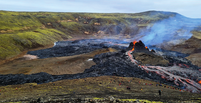
Intense seismic activity lead to a volcanic eruption in the valley of Geldingadalir (Iceland)
A small volcanic eruption started in Geldingadalir valley in Fagradalsfjall mountain, about 25 km SW of Reykjavík capital region, on Friday night 19 March 2021. The eruption was preceded by 3 weeks of intense earthquake activity and tectonic rifting episode, associated with a dike injection. The earthquake activity started on February 24, when a Mw5.7 earthquake took place in the same area. The new TURNkey network deployed in the region (see figure 1) recorded about 2500 earthquakes larger than Mw during this sequence. The 24 hours before the eruption, the rifting and seismicity died almost completely down. Once the eruption started, there was a persistent tremor at 2-4 Hz on the closest seismic station, but very low seismicity. As a result, very few events have since then been measured on the vertical seismometers of the TURNkey urban array in the town of Grindavík. However, the network monitors in real time seismic ground motion in the towns, and on rural stations.
The eruption (live feed here) (figure 2) is an effusive type on a short extensional fissure that now has concentrated into two main craters that are gradually being built up by tephra, and periodically collapse with lava floods flowing out onto the new lava field. The eruption is taking place in a small enclosed valley, and if it continues a large lava pool may be formed. The eruption is being fed from a deep rooted source within the mantle, most likely via a 1 m wide dike, that is about 3 km tall and a few km long according to modeling by deformation experts, and could potentially be long-lasting.
Well prepared hikers can even get close to the volcano and watch this phenomenon up close (see figure 2). The dispersion of the volcanic gases with the wind are being monitored and forecasted by the Vedurstofan Icelandic Meteorological Office, and while the levels appear to be mild, as this type of eruption usually is less gaseous than others, hikers are instructed to approach and stay upwind from the eruption, and away from depressions where poisonous gases may accumulate, in particular in low-wind conditions.
Testbed 3 (Iceland) of the TURNkey project is actively deploying additional stations in the area to monitor seismic ground motions in real time, producing data that are being used to develop and test the TURNkey platform.

-
Figure 1. The TURNkey seismic network in southwest Iceland (triangles). The eruption location is illustrated by the schematic symbol of a volcano on left. The vertical geophone of the instrument monitors real-time earthquake ground motions and their progression across the network. Station color indicates the average noise level at the stations that varies with natural and man-made nearby disturbances.

-
Figure 2. The main volcanic crater with orange lava flowing out of it, forming the most recent flow (light-gray) on top of its previous lava (black), with volcanic gases being emitted from the crater and the new lava field (blue). The eruption has been a big attraction with hundreds of people hiking every day to the volcano site. (Photo taken towards north, by Björn Oddsson).

