
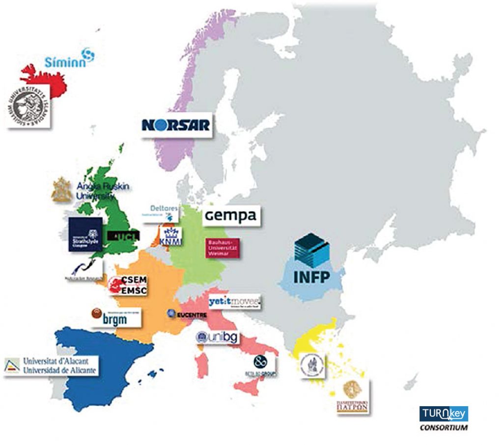
The TURNkey consortium consists of 21 partner institutions from several countries belonging to the European Union (figure below). These 21 partner institutions with complementary and inter-disciplinary competences comprise: 8 universities (UIce, UStr, BUW, UA, ARU, UNIBG, UCL, UPat), 7 scientific research and technology organizations (EUC, BRGM, KNMI, INFP, NOA, EMSC, DEL), and 6 small and medium enterprises specialized in instrumentation (YET, GMP), telecommunication (SIM), database and real-time analysis tools (B80, GMP, NOR), and a market research consulting company (NTC).
Coordinator
Stiftelsen NORSAR
NORSAR was established in 1968 as a joint undertaking between the governments of Norway and the USA. NORSAR is today a private Norwegian research foundation that conducts research, development and advanced advisory work in the fields of seismology, applied geophysics and earthquake engineering and one of the world’s largest seismological observatories with more than 45 years of experience with advanced seismological data processing, analysis and parameter extraction in near-real time. NORSAR operates one of the largest seismological networks in Europe and thereby has huge experience in seismic instrumentation, technical laboratory equipment and solutions for data transmission and storage. NORSAR has been a main contributor to the technology presently being implemented at the International Data Centre (IDC) in Vienna for verification of the Comprehensive Nuclear Test Ban Treaty (CTBT). NORSAR is a registered small medium enterprise (SME).
NORSAR has been conducting research, development and consulting within earthquake hazard and earthquake risk analysis since 1975. More than 135 earthquake hazard and risk related projects have been conducted in Norway and many other countries, including studies for nuclear and hydroelectric power plants, dams, tunnels, waste facilities, offshore platforms and pipelines, petrochemical facilities, as well as design, installation and operation of seismic monitoring networks, with associated earthquake hazard analyses. Since 2004, NORSAR started to widen its competence into earthquake engineering and earthquake risk assessment, thereby creating a multidisciplinary work environment where earth scientists, engineers and IT specialists closely work together on various tasks. NORSAR has a wide experience in the initiation and management of large international research collaboration projects many focusing on earthquake hazard assessment, risk reduction and disaster mitigation studies in developing countries. In the past 25 years, NORSAR has been thereby able to create a worldwide network with researchers, officials and decision makers from educational institutions, academia, governmental bodies and NGOs in almost every part of the world. Of late, the development of innovative technical solutions contributing to a safer society is one of NORSAR’s core areas; e.g., conceptualization and installation of near-real-time earthquake loss information systems which establish a major disaster mitigation measure for earthquake-prone cities and regions.
Participants
Haskoli Islands
The University of Iceland (UIce), founded in 1911, is a research led state university in Reykjavík, Iceland. UIce offers internationally competitive undergraduate and graduate programs based on the Bologna system. The University employs over 1.500 people and has over 14.000 students, 500 of which are PhD students. The Times Higher Education Supplement ranks UIce at 222 for the top Universities in the world. The Faculty of Civil and Environmental Engineering (FCEE) at the School of Engineering and Natural Sciences (SENS) has a faculty of 13, 184 students and 4 PhD students. The Faculty has a strong international research cooperation and obtains research funding from both National and International sources.
The University of Iceland has participated in numerous projects under the FP6, FP7 (UIce: 52, SENS: 32 projects, 2 ongoing) and H2020 (UIce: 27, SENS: 20 projects, 4 thereof coordinated by SENS), both as a coordinator and as a project partner. SENS also participates actively in a multitude of Nordic, national and international projects including funds from NASA and NIH. All the H2020 projects are managed through the Project Management Office at the University of Iceland, housed at SENS. The Earthquake Engineering Research Centre of the FCEE, SENS, has a long-standing experience of using instrumentation to collect data for research, applied research, consultation and for managing seismic risk.
University of Strathclyde
The University of Strathclyde was awarded the titles of the University of the Year 2012 and Entrepreneurial
University of the year 2013 by THE. It was awarded five stars in the most recent QS. The Department of Civil and Environmental Engineering was ranked eighth in the UK in the latest REF. The Department is currently the only civil engineering department in the UK with an Athena SWAN Silver Award. The Department’s Centre for Intelligent Infrastructure is committed to transforming traditional structural engineering through cross-disciplinary research, recognising and transposing the recent radical innovations in material science, communication and sensor technology. The four key personnel of TURNkey from this Centre have considerable skills and experience in seismic hazard and risk evaluations, including within the field of earthquake early warning and operational earthquake forecasting, as well as sensor design, structural health monitoring and decision support systems.
Earthquake Damage Analysis Center, Bauhaus-Universität Weimar
The Earthquake Damage Analysis Center (EDAC) is entirely integrated in the educational routine of Bauhaus-Universität Weimar, participating mainly in the International Master’s Course “Natural Hazards and Risks in Structural Engineering (NHRE). The course is directed by the Head of EDAC (see: www.uni-weimar.de/nhre). A series of lectures are given biannually on the following topics:
– Seismic monitoring;
– Building stock survey; GIS (in cooperation with CV, BUW);
– Earthquake engineering and structural design;
– Design concepts and building testing methods;
– Hazard projects and Advanced Geotechnologies (In Cooperation with Geo Research Center Potsdam);
– Risk projects and Evaluation of Structures; and
– Flood Management.
Since 1992, scientific staff of Bauhaus-Universität Weimar has joined missions of German TaskForce for Earthquakes.
Since 1999, the engineering group hosted at Earthquake Damage Analysis Center (EDAC) has initialized, organized and conducted several field missions at their own responsibility (see www.edac.biz ⇒ research ⇒ earthquakes ⇒ Field missions.
Ongoing research is related to new seismic action model for German earthquake regions and the elaboration of experience- and performance-based design criteria.
Since 2006, the working field was extended to other natural hazards like floods and storms. Principal methods and approaches for the empirical vulnerability and damage assessment are the basis for the development of a damage and loss prognosis tool to correlate flood action and building’s resistance-type parameters. EDAC has initialized, organized and conducted several field surveys in affected areas in Germany (see: www.edac.biz ⇒ research ⇒ Flood ⇒ field missions).
Universidad de Alicante
The University of Alicante (UA) was created in 1979. Today it educates and trains more than 36.000 students – 2.500 of them are international students – and offers more than 80 undergraduate and 96 postgraduate programs. It is one of the fastest growing universities in Spain. The UA houses 227 research groups in Social and Legal Sciences, Experimental Sciences, Technological Sciences, Human Sciences, Education and Health Sciences and 15 Research Institutes (Water & Environment, Materials, Electrochemistry, Biodiversity, Chemical Processes and Organic Synthesis, and Modern Languages, among others). Thus, the UA employs over 2.400 researchers/ professors and has a complex management /administration structure of 1.300 people, which involves an annual budget of 175 million Euros.
Within the University, the Technology Transfer Office is responsible of all industrial liaison activities and aims to increase cooperation between the University and companies and to promote international activities of regional companies via the Office for International Project Management (OGPI). The office managed the IPRHelpdesk project for 15 years. The UA has been involved in the creation of 12 EBT since year 2010 on an average of two per year and has managed the application of 48 patents.
UA is a young and dynamic university with vast experience in implementing EU funded projects in different programmes and areas, with experience in more than 60 countries worldwide. In the last 10 years, UA has successfully acted as coordinator of many Tempus, Alfa, Edulink projects involving Third Countries, LIFE+ and ERASMUS+, FP7 and H2020 Projects. Moreover, the participation in FP has been increasing in the last years, taking part in 25 FP5, 26 FP6 and 42 FP7 projects (21 of them coordinated by UA) and 27 projects H2020 (2 coordinated by UA).
The campus is considered one of the best campuses in Europe: one million square meters with the best urban design, the most innovative architecture in a framework of environmental excellence (large green areas, landscape design, pedestrian, cultural, sporting, educational areas…) and a wide variety of services. In addition to the strong commitment by the innovation and technology, the University of Alicante reaches the most prestigious heights in its firm commitment to culture and heritage.
The University of Alicante is firmly committed to high-quality work and one of its priorities is the development of intense research activity that contributes to the generation and transfer of knowledge. Therefore, we promote the research through our research groups. Related with the task in this proposal, the main research group involved will the Earthquake Engineering and Seismic Risk Research Group (https://web.ua.es/en/girs/earthquake-engineering-university-of-alicante.html) that also has a strong cooperation with other research groups as the Architectural Restoration research group (http://gira.eps.ua.es/) and the Building modelling Research Group (https://blogs.ua.es/gresmes/). Additionally, the UA is responsible of a small seismic network (https://web.ua.es/en/urs/seismic-record-unit.html) with the main objective of being a research focal point related with the seismicity and seismic risk in the Valencian community.
Anglia Ruskin University
Anglia Ruskin University (ARU) is an innovative global university, with students from 185 countries studying its courses. ARU are consistently named in the top 350 institutions in the world in The Times Higher Education’s World University Rankings and annually partners with about 2,000 enterprises through training, research and collaborative programmes. ARU’s Department of Engineering and the Built Environment (EBE) is a multidisciplinary Department whose activities range from Architecture, through Engineering to Urban Design and Project Management. EBE has a strong track record in collaborative interdisciplinary research with industry and public authorities that links engineering solutions to societal challenges. EBE’s current research activity is focused on the systems and services required for future city living. In particular: community resilience to natural and man-made disasters; future service design and service delivery models; support for an ageing population; and sustainable technologies. Of particular relevance to the TURNkey project are the H2020 LIQUEFACT project, which is led by the Department, the FP7 RECONASS project in which engineers from the Department developed a sensor for real-time assessment of post disaster damage and the EPSRC funded CREW project in which the Department developed a community resilience model for extreme weather events.
Università degli Studi di Bergamo
The University of Bergamo is an Italian State University with about 16,000 students, and more than 300 PhD students. With 6 departments and a staff of 656 members (331 permanent professors and researchers, 95 assisting academic staff and 230 administrative and technical staff) it provides a dynamic scientific and teaching environment open to innovations. In particular the Department of Management, Information and Production Engineering has 54 people, including professors and researchers. It contributes to national and European research projects. Moreover, it collaborates in many industry-funded research projects.
University College London
University College London (UCL) was founded in 1826 to open up higher education in England to those who had been excluded from it – becoming the first university in England to admit women students on equal terms with men in 1878. UCL, with its 840 professors and more than 6,000 academic and research staff who are dedicated to research and teaching of the highest standards, is ranked seventh in the world’s top 10 universities by the QS World University Rankings (2018). The UCL Institute of Education is ranked number one for education. Students from 150 countries study at UCL, making up more than one-third of the student body. 52% of the nearly 36,000-strong student community is engaged in graduate studies, with nearly a third of these graduate students pursuing research degrees. UCL is one of the most successful UK universities at attracting funding, with an income of more than £1 billion in 2017. UCL research income has constantly increased over the past five years. This included receiving the highest allocation of Research Council UK funding and being the UK’s top participant in EU collaborative research. The 2014 Research Excellence Framework (REF) gave UCL a ‘grade point average’ of 3.54 (out of 4) for the real-world impact of its research, placing it among the top comprehensive universities rated. In particular UCL was the top-rated university in the UK for research strength, by a measure of average research score multiplied by staff numbers submitted. It was rated top not only in the overall results, but also in each of the assessed components: publications and other research outputs; research environment; and research impact.
UCL’s involvement in TURNkey consists of UCL’s Earthquake and People Interaction Centre (UCLEPICentre) which is part of the Department of Civil, Environmental and Geomatic Engineering (UCL CEGE) UCL-CEGE has a total grant portfolio of more than £35 million – UK’s largest Engineering and Physical Sciences Research Council (EPSRC) portfolio in civil engineering. The research carried out within UCLCEGE reflects a broad multidisciplinary view of the engineering world, making constant reference to the needs of society and the planet, which drive the requirement for innovative engineering solutions to create a better world. Research is organised around interdisciplinary centres, including UCL-EPICentre, the UK’s leading natural hazard risk analysis and disaster mitigation research centre with expertise on engineering seismology, civil, structural and mechanical engineering, social science and statistics. UCL-EPICentre brings together the wealth of knowledge and expertise across the university, and through research, teaching, public engagement and knowledge exchange aims to improve the understanding of risk and overcome the barriers to increasing resilience to disasters.
UCL-EPICentre has received funds from EPSRC, Natural Environment Research Council (NERC), the World Bank (WB), UK’s Department for International Development (DFID), European Research Council (ERC), European Union’s Seventh Framework Programme (EUFP7), Horizon 2020 and several industrial partners (e.g., Willis Re).
Panepistimio Patron (University of Patras)
University of Patras is one of the leading research and teaching institutions, and the fourth largest, in Greece.
It is constantly aiming for excellence through the creation, utilization, transfer and application of knowledge.
Its success is built on a strong partnership with its students and academic staff and a clear focus on high performance, enhancing UPat’s position as a world-class university with a strong academic reputation and a commitment to excellence. UPat has acquired international prominence for pioneering and wide-ranging research in areas such as Environment, Health, Biotechnology, Engineering, Electronics, Informatics and basic science. A number of its Departments, Laboratories and Clinics have been designated as Centres of Excellence, on the basis of international assessment. UPat formally fosters and achieves interaction and collaborations with Universities and Research Institutions worldwide engaging in and developing joint activities related to research, teaching, intensive programmes and common curricula, establishing bilateral agreements (already 200 with 55 countries), as well as participating in International & EU Educational Organizations, Networks and University Associations (EUA, EUCEN, BSUN, UNECC, CMU, UNIADRION, AESOP, etc) ensuring that UPat remains at the forefront of global developments. UPat’s Special Account for Research Grants has received accreditation, issued by the Ministry of Education, for Managerial Competence since 2009, certifying the administrative efficiency and capacity for the implementation of co-funded projects and programmes.
EUCENTRE Foundation – Fondazione Centro Europeo di Formazione e Ricerca in Ingegneria Sismica
EUCENTRE Foundation, European Centre for Training and Research in Earthquake Engineering, based in Pavia (Italy), is a non-profit organisation that promotes, supports and sustains training and research in the field of risk mitigation. The EUCENTRE was founded in 2003 by the following institutions: Italian National Department of Civil Protection, University of Pavia (Italy), Italian Institute of Geophysics and Volcanology (INGV), Institute of Advanced Study (IUSS) of Pavia (Italy). The core activities of the Foundation are: applied research in the field of earthquake engineering, with a view to improve existing practice in assessment and reduction of seismic vulnerability and risk; support work towards the development of guidance documents for both practitioners and governing bodies, bringing international state-of-the-art into Italian design codes and regulations; scientific and technological consultancy, at both national and international levels; training for practitioners and technicians.
EUCENTRE coordinates national and international programmes of research and education and has established numerous research programmes with institutions from other European and non-European countries. As a reflection of its multi-disciplinary character, the research activities at EUCENTRE include several fields related to assessing hazard and risk due to different natural events, with the objective of producing and disseminating hazard and risk information and of developing risk mitigation solutions that can be applied by practitioners and industries alike. Although EUCENTRE’s research is multi-hazard in nature, a wealth of experience in national and international seismic hazard and risk assessment is at the core of its activities. A variety of themes are covered, from the vulnerability assessment of structures and infrastructures to coordinating the development of a holistic global seismic risk model.
EUCENTRE, being centre of competence of the Italian Department of Civil Protection has participated, since the foundation, to emergency activities giving support in post-earthquake reconnaissance investigations. Through the participation to research projects on emergency (i.e., project funded according to DG-ECHO scheme), EUCENTRE experienced modern post-earthquake survey techniques using drones and adopting cloud computing services to collect and process data.
Bureau de Recherches Géologiques et Minières
BRGM (www.brgm.eu) is a French public institution, providing technological research and development, as well as expert support for public policy and citizen information in different fields of the Earth Sciences.
Activities at BRGM cover areas such as observation, mapping and databases, modelling and management of surface and subsurface resources and processes, protection of the environment and mitigation of natural risks, etc. BRGM also provides support for European Union policies in partnership with other Geological Surveys (EuroGeoSurveys).
Since 2006, BRGM has held the Institute Carnot certification. As an equivalent of the German Fraunhofer, it is part of 34 major research structures in France dedicated to fostering companies’ innovation. Each member institute commits to develop research that contributes to the development of innovative services and products for business, to create wealth and employment in France and Europe. BRGM project management excellence has also earned it the ISO 14001 certification.
BRGM has coordinated or contributed to several EC projects in the fields of risk and vulnerability evaluation, particularly on critical infrastructure, multi-risk assessment and rapid response systems, as well as national projects (ANR, National Research Agency) on risk assessment and mitigation. An achievement was BRGM participation in the FP7 project SYNER-G, to date the most complete European project on estimating earthquake impacts on critical infrastructures.
The Risks and Prevention Division (DRP) at BRGM comprises teams of renowned scientists with international experience in the fields of geotechnical, earthquake, and coastal engineering as well as crisis management, including the development of risk modelling tools, such as ARMAGEDOM to model earthquake physical impacts and human losses.
Koninklijk Nederlands Meteorologisch Instituut – Royal Netherlands Meteorological Institute
The Royal Netherlands Meteorological Institute (KNMI) is a governmental agency under the Dutch Ministry of Infrastructure and Water Management. The KNMI has about 400 employees of whom 200 are scientists with key expertise in physical and dynamical meteorology, climatology and seismology. The KNMI provides advanced data, knowledge, information and advice on weather, climate and seismology and conducts modelling research, observational research and applied research in each of these areas.
The department R&D Seismology and Acoustics is specialized in applied research, like seismic hazard, observational technologies, induced seismicity and infrasound. The department is responsible for the determination of epicentre, magnitude and depth of both tectonic and induced events in the Netherlands, and the attribution of their causes. Within a few minutes after an event, detailed event info is published. Data are acquired (monitoring using an extensive national seismic and acoustic network), interpreted (analysis and research) and distributed (data dissemination). The department also monitors the volcanic activity in Saba and St. Eustatius and runs an earthquake monitoring and tsunami warning system for Bonaire, Saba and St. Eustatius. Outside the Netherlands, detection, localization and characterization of nuclear events is performed. The department has an advisory role to the national government, the industry and the general public regarding in these matters.
Institutul National de Cercetare si Dezvoltare pentru Fizica Pamantului
The National Institute for Earth Physics (INFP) has a long experience in the basic area of the project and was involved as partner or leader in many national/international projects. INFP is the leading institution for seismology in Romania and it is responsible for the seismic and geodetic monitoring of the territory. INFP has a wide background in basic and applied researches in Earth sciences, with a focus on seismic source and seismotectonics, seismic hazard and risk assessment, engineering seismology and earthquake prediction. As an institution recognized by the Ministry of Research and Innovation, INFP is actively participating in: (i) structuring the strategy in the Earth physics and related domains, (ii) coordination of research activities at the national level, particularly in Seismology and generally in Earth physics, (iii) evaluation and approval of projects and human resources, (iv) professional training and specialization, (v) consulting and expertise in Earth physics, (vi) providing scientific and technological services to protect people and infrastructure from earthquakes an (vii) being the national representative in international organizations and boards. INFP started the development of its own real-time seismic network in 2002. At present the network consists of 115 seismic stations and two seismic arrays. The seismic stations are equipped with Quanterra Q330 or Basalt digitizers, broad-band seismometers or short-period sensors. At present, INFP has a network of 150 accelerometers in real time, out of which 25 are installed in Bucharest where 5 important buildings are monitored. Three of these buildings are suspended on seismic insulators. The equipment is connected in real time with the National Data Centre. A completely automated seismological system Antelope runs at the Data Centre in Magurele and provides automatic event detection, arrival picking, event location and magnitude calculation. Also, we calculate in real time various strong-motion intensity measures, e.g., PGA, PGV, PGD, SA, IA and CAV. A GPS network has been developed to monitor crustal movements in Romania. NIEP also operates a real-time geophysical network named The Romanian Electromagnetic Field and Infrasound Monitoring Network (MEMFIS) and is part of the International Network for Frontier Research on Earthquake Precursors (INFREP). For this project we will focus on the development of a system of alerting and ensuring the continuity of activity in the event of an earthquake for monitored buildings in Bucharest. INFP has knowledge about geology and geotechnical data of Bucharest.
National Observatory of Athens (Institute of Geodynamics)
The National Observatory of Athens within the Institute of Geodynamics (www.gein.noa.gr) is a National Research Center of the Greek Government. The Institute of Geodynamics (NOA) was established in 1893 with research activities that cover a broad spectrum of Physics of the Earth’s Interior, focusing on Seismology and Geophysics. NOA main tasks are: monitoring and processing of various seismological-geophysical parameters, elaboration of research projects and relevant studies, training and services provided to third parties. NOA operates the National Seismic Network (bbnet.gein.noa.gr, 54 broadband stations) covering the whole of Greece, coordinates the Hellenic Unified Seismic Network (HUSN) that joins the permanent seismic networks in Greece (over 130 real-time broadband stations), operates a permanent strong motion network of 150 digital accelerographs (80 real time) and operates several small local accelerometric networks dedicated to monitor responses of important heritage sites and monuments (e.g., the Athenian Acropolis Accelerometric Array). Information services facilities regarding shaking and earthquake intensity estimation are available online and in real time. Worldwide standard software like ShakeMap and VS are in operation giving information on all events over magnitude 4 in the Greek region. The extended HUSN broadband network and the incorporated National Accelerometric Network provide important data for all major earthquakes in Greece and adjacent regions. Recently, a newly deployed accelerometric array is in trial operation in the Patras region, western Greece. It consists of ten low-cost accelerometric stations, equipped with P-Alert type MEMS units, mainly deployed in the city of Patras. It serves the purpose of exploring strong-motion recordings with a combination of instrumentation (accelerometers, accelerometric alert devices and low-cost USB acceleration sensors) towards an EEW local system. It combines schools, public buildings and private houses for local seismicity monitoring, providing strong-motion information and through that intensity estimation in real time, thus connecting “school” and “citizen” seismology operations with real-time results for the public and engineers.
Euro-Mediterranean Seismological Centre
The Euro-Mediterranean Seismological Centre (EMSC), a not-for-profit NGO federates seismological observatories in the Euro-Mediterranean region, it is one of the top global earthquake information centre in
the world and a key data and product provider for the seismological research community.
EMSC has 85 seismological observatories from 56 countries as members and promotes research and collaboration among its members in association with partners such as UNESCO. It has been pioneering citizen seismology, from participatory projects such as LastQuake to the support of citizen-operated seismic networks. LastQuake is at the intersection between seismology, citizen science, and digital communication, its aim is twofold: to offer timely, appropriate information in regions where an earthquake is felt (from earthquake information to guidance after strong shaking and safety checks) and to collect high numbers of eyewitnesses’ direct and indirect observations about the degree of shaking being felt and possible damage incurred. This, in turn, improves rapid situation awareness and augments data at low cost. This strategy implies a strong presence on social media through a LastQuake smartphone app (280 000 users), eponym Twitter and Telegram quakebots (70k followers) and websites (www.emsc-csem.org, 2M visits a month), a multichannel approach linking these different components together as well as an extensive use of visual communication to ensure a truly global service. Through their online reactions, eyewitnesses act as real time seismic sensors, reacting within seconds of the tremor and opening the way to explore crowdsourced earthquake early warning system. EMSC is part of the project ARISTOTLE (both pilot and current projects) delivering world leading multihazard capability to the Emergency Response Coordination Centre (ERCC) of the European Civil protection mechanism and its smartphone app has been further developed in CARISMAND project which deals with the cultural factors in the perception of risks.
Thanks to its federative role for earthquake observations, EMSC has been leading the developments of the seismological portal (www.seismicportal.eu) based on open source software and OGC compliant webservices during two I3 (infrastructures) EC-projects, NERIES and NERA and the current ESFRI initiative EPOS (European Plate Observing System). It offers data access for researchers, contribute to the development of standards and leverage data exchange and data uses.
Stichting Deltares
Deltares is a leading (not-for-profit) and internationally operating specialist consultancy and applied research institute in the field of water, subsurface and infrastructure. Deltares works on innovative solutions and applications for people, environment and society. Deltares is an independent research institute and specialist consultancy (>800 employees) for applied research and specialist advice in the field of geo-engineering and hydraulic engineering with special reference to delta and coastal areas, including urban areas. Deltares is based in Delft and Utrecht, in the Netherlands. Moreover, Deltares has offices in Singapore, Indonesia (Jakarta), Australia, Abu Dhabi, Latin America and the USA (Deltares USA Inc., Silverspring).
Deltares was founded in 2008, by fully merging four existing institutes: Delft Hydraulics (founded in 1927), GeoDelft (founded in 1934), the Soil and Groundwater department of TNO and the research departments of the Dutch Department of Public Works, Transport and Water Management.
One of the activities of the Unit Geo-Engineering of Deltares is the risk assessment and risk management of buildings and infrastructures under multi-hazard scenario. The Unit is deeply involved in the activities related to the effects of the induced seismicity due to gas extraction in the Groningen province, in the North of the Netherlands. From one side, projects are carried out to better define the site amplification effects improving the definition of the seismic hazard at surface. Other projects are related to the identification of the liquefaction potential in the subsoil of Groningen. Others are focused on the seismic assessment of structures and infrastructures, e.g., levees and pipelines, taking into account also the liquefaction assessment.
Yetitmoves SRL
YETITMOVES is an innovative start-up founded in 2017, whose mission is scientific research, the design, development, production and commercialization of high-technology solutions and services in the field of geomatics, computer technology, electronics and space.
In particular, based on the twenty-year experience of its founding partners, YETITMOVES has a solid experience in GNSS data processing for high-accuracy static and kinematic positioning applications.
YETITMOVES develops and commercialize DISPLAYCE, a low-cost Internet-of-Things (IoT) solution based on GNSS receivers for monitoring and early-warning of natural hazards. At present, several networks of DISPLAYCE receivers have been deployed in Italy to monitor ground displacements caused by landslides (threatening villages, roads or railway lines) or by anthropic activities (e.g., natural gas storage sites). Among its customers and end-users, YETITMOVES can list both private companies (energy, utilities, transportation, geotechnical) and public agencies (research institutes, local administrations, universities).
Gempa GmbH
GEMPA develops and supports software for natural hazard monitoring, in particular earthquake monitoring and earthquake and tsunami early warning. GEMPA is a commercial spin-off of the German Research Centre for Geosciences (GFZ), and nowadays the primary developer of the SeisComP3 seismic real-time analysis system, developed at GFZ. SeisComP3 is a key component of many earthquake monitoring and earthquake early warning (EEW) institutes. This includes the development of multi-format data transmission protocols specialized on EEW as well as ready to use EEW modules. GEMPA also develops ShakeMap and Structural Health Monitoring modules to estimate the impact of seismic hazard. Commercial support for GEMPA products includes installation, training, maintenance and software development. GEMPA cooperates with major warning centres, research institutes and companies world-wide, and its software is used in over 60 countries.
Siminn hf.
Siminn is the largest telecommunication provider of Iceland. Siminn´s participation will enable the company to explore and develop the infrastructure needed for network redundancy with the capacity of serving multisensory units nationwide. The use of LPWA (NB-IoT, LTE-M etc.) networks for more environmentally-friendly devices along with the typical 4G and fixed networks is an important exploration aspect of the project. It is important for Siminn to explore how we can build the network for the multi-sensor units so the redundancy will be at the highest level possible and if the use of data from the multi-sensor units can decrease response time if there is a failure in the network.
BETA 80 Spa Software e Sistemi
Beta 80 S.p.A. (henceforth “Beta 80”) is part of Beta 80 Group (www.beta80group.it), along with four other companies, each devoted to a specific technology and market. The Group has a turnover of 42 million euro. Beta 80 is the group’s largest company, employing over 250 people with a turnover of 25 million euro. It is ISO 9001 – UNI EN ISO 9001 (2008) compliant and certified by IMQ (www.imq.it), the European certification agency and validated by Accredia (www.accredia.it).
Beta 80 started its journey in Milan, Italy’s business capital and one of Europe’s most dynamic cities. It has now become a leading company in Public Safety Solutions worldwide. As of today, Beta 80’s technologies cover Law, EMS, Fire, Healthcare Continuity and Civil Defence. Every day, our solutions protect 38 million citizens with a 100% customer retention rate. Beta 80’s mission is to support customers in their Digital Transformation. Beta 80 is making the digitalization of PSAPs and Emergency Control Rooms possible by empowering local operators and agencies with the world’s most advanced tools and solutions through which they can manage their daily operations in a simple, innovative way. Beta 80’s solutions are based on proprietary technological platforms and the market’s best components.
Beta 80 Emergency and Crisis solutions help plan and prepare for any emergency event and monitor the situation in real time with key technologies such as Geographical System, Unified Communication System, integrated Intelligent Notification, integrated external sensors in a unique software platform. Beta 80 currently serves over 60 control rooms, connecting to remote Control rooms via WAN or LAN, and integrating with several third-party systems, such as PBX and telephonic networks, radio systems, AVL systems, GIS systems, vehicular devices based on UMTS / 4G technologies, diagnostic devices, surveillance systems. Our products come from our 30-year experience in the Public Safety market and our close relationship with partners and customers, combined with the newest technologies in data management, geolocation and mobility. We believe the greatest asset for a company is the ability to create a network of positive connections from which to learn and grow. Thus, in over three decades we have continued to grow and invest in our product and service lines whilst never losing a single customer.
Nutcracker Research Ltd.
Nutcracker Research is a market research agency with expertise in concept-to-market studies especially in the fields of consumer technology, financial services and professional organisations. The core of its business is interrogating citizens, using both qualitative and quantitative methodologies, to advise clients on best ways to market; including innovation, new product development and communications planning.