
TURNkey aims to make significant advances in the fields of:
- Operational Earthquake Forecasting (OEF) by collecting all available earthquake-hazard related information for the regions of interest (long-term) and by monitoring the regions with the multi-sensor-based earthquake information system (short-term). A critical point is to develop accepted criteria to validate any observed changes and the dissemination of any warnings. Moreover, another critical point will be the translation of the assessed time-dependent hazard into a format that is understandable and useful to the intended end-users of the forecasts. This entails transforming the OEF outputs into statements about risk through close interactions with potential end users and social scientists.
- Earthquake Early Warning (EEW) by distributing reliable information that an earthquake is happening as fast and efficiently as possible to all stakeholders hence mitigating earthquake losses. TURNkey will improve existing systems and approaches for estimating the location and intensity of earthquakes, by providing more accurate estimates of imminent earthquake ground motions. This requires increasing the potential of existing crowdsourced systems, developing low-cost multi-sensor instruments that can be deployed in the monitored areas, and advancing current probabilistic methodologies for estimating ground-motion characteristics by propagating the various uncertainties inherent to the problem.
- Rapid Response to Earthquakes (RRE) by informing relevant stakeholders about the most probable damage scenarios. The aim is not only to forecast and issue warnings for main shocks but also for aftershocks. Shake maps will be generated for the areas struck by the earthquake, and the spatial data on the ground-motion parameters will be integrated with vulnerability curves of the building stock to estimate direct and indirect losses. The multi-sensor instruments will monitor fast ground motions (seismic) and also slow movements, e.g. foundation settling and structural creep, using Global Navigation Satellite System (GNSS) instruments.
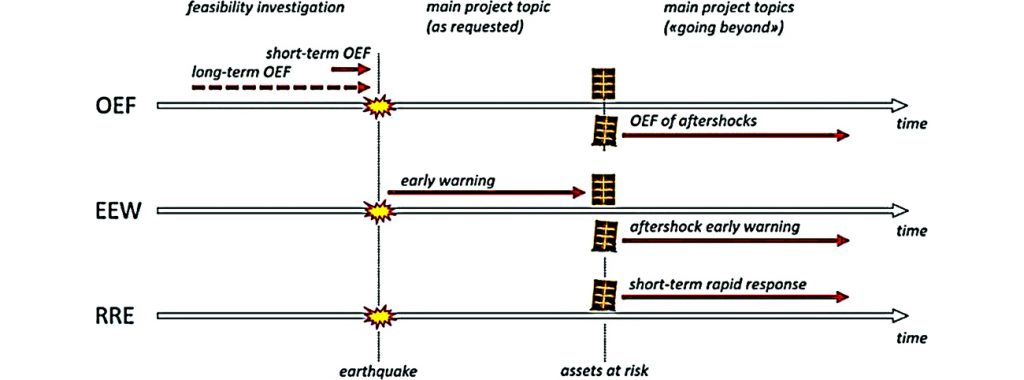
Illustration of the chronological sequence of Operational Earthquake Forecasting (OEF), Earthquake Early Warning (EEW) and Rapid Response to Earthquakes (RRE).
TURNkey’s purpose is to develop the TURNkey FWCR (Forecasting – Early Warning – Consequence Prediction – Response) platform, a multi-sensor-based earthquake information system, facilitating Earthquake Forecasting and enabling Early Warning and Rapid Response actions, and a versatile and cost-efficient TURNkey multi-sensor unit consisting of seismic (vibration) sensors optimized for EEW and GNSS receivers suitable for various monitoring tasks (structural health monitoring, monitoring of rockfalls, rock/landslides, avalanches, tsunamis) and installation possibilities (free field vs building/infrastructure, field vs urban deployment).
TURNkey will be demonstrated in eight Testbeds: TB-1 to TB-6 refers to European Testbeds, representative of six earthquake-prone areas in Europe, including areas affected by induced seismicity; TB-7 is a Worldwide Testbed; TB-8 represents a mobile European Testbed for aftershocks.
TURNkey’s purpose will be attained by exploiting synergies among key actors, exploring data from existing sensor networks, and building on the infrastructure developed in various European TBs, fostering international collaboration, and affiliating with past and ongoing initiatives beneficial for/of interest to the project’s success.