
Testbed, Partners:
TB-3 – Hveragerði, South Iceland and Húsavík, North Iceland – UIce (YET, GMP, SIM, UPat, NOR)
Area:
15 km2
Affected population:
4,500
General building stock inventory:
Available
Existing infrastructure:
Roads, bridges, schools, hospitals, harbour, pipelines, boreholes, industrial facilities
Key stakeholders: Municipality of Hveragerði; Municipality of Norðurþing, Húsavík; HSN Health Care Institution of North Iceland, Húsavík; The Icelandic Meteorological Office; Landsvirkjun Energy Company; OR Power; PCC Silicon; ICI Icelandic Catastrophe Insurance Company; National Commissioner of the Icelandic Police; IRCA Icelandic Road and Coastal Administration; RARIK Icelandic State Electricity Providers; Samorka, the federation of energy and utility companies in Iceland.
Existing Sensor networks:
ICEARRAY I (strong-motion, Hveragerði, South Iceland), ICEARRAY II (strong-motion, GNSS-GPS, Húsavík, North Iceland), Icelandic Strong-motion Network, operated by the Earthquake Engineering Research Centre of the University of Iceland; the National Seismic Network (SIL), the GNSS National Network, other geophysical monitoring systems of the Icelandic Meteorological Office.
TB-setting and seismic hazard:
Iceland is the most seismically active region in north-western Europe. The seismic hazard is the highest on two large, complex and populated transform zones, the South Iceland Seismic Zone (SISZ) and the Tjörnes Fracture Zone (TFZ) in the North. The existing infrastructure monitors tectonic and earthquake ground motions, along with structural monitoring of key buildings. The ICEARRAYs comprise the densest urban monitoring systems of earthquake strong-motion in Europe. In addition, ICEARRAY II monitors tectonic motions across the Húsavík-Flatey Fault.
During TURNkey:
A total of 56 TURNkey multisensor units (50 accelerometers and 6 GNSS instruments) will be deployed, thus densifying the free-field urban arrays even further and testing the limits of the TURNkey platform EEW and RRE information in urban areas, and adding structural monitoring systems. The instruments will also be distributed on top of the large faults EEW and RRE purposes. For OEF and EEW purposes, real-time measurements of other geophysical markers (GPS, strain, seismicity etc.) from stations of the other geophysical networks in the region will be made accessible to the TURNkey platform. Additional and existing instruments contributed by UIce will be deployed in the seismic zones as a part of TB-3 to monitor SISZ seismicity, providing reliable and crucial first P-wave signals for EEW.
Instrumentation
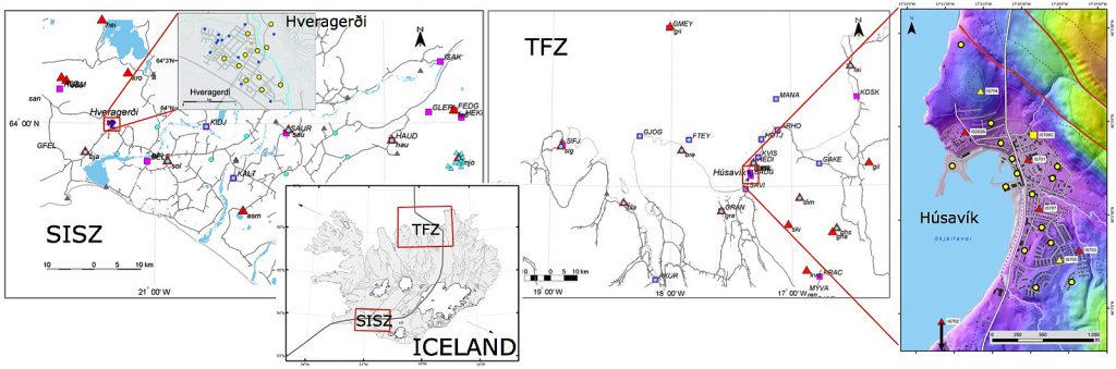
TB-3 – Hveragerði in the South Iceland Seismic Zone (SISZ, left) and Húsavík in the Tjörnes Fracture Zone in the North (TFZ, right). The planned TURNkey instruments, shown in circles: yellow (urban, for EEW) and cyan (rural, EEW and OEF), are either new stations or collocated with existing GPS (squares) and seismic (triangles) stations.