The Thessaly, central Greece, damaging 6.3Mw earthquake of March 3, 2021
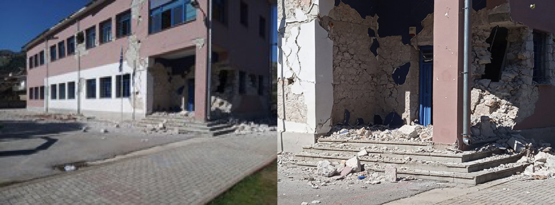
A strong earthquake of magnitude 6.3Mw, hit the region of Thessaly, central Greece, on March 3, 2021, at 10:16 UTC, injuring at least 12 people and causing a great damage to hundreds of buildings in the rural area west of the towns of Tirnavos and Elassona and including the villages of Damasi, Mesochori, Vlachogianni and Zarkos. Crowds in the greater area and especially in Larissa main city (~24km SW of the epicenter) panicked and rushed into the streets. An elderly disabled man in Mesochori village was trapped in his house by a falling wall (he was freed from the rabble but four days later died in hospital). 60 children at school in Damasi, managed to leave the 80 year old building unharmed, thanks to preparation exercises and awareness seminars utilized by the Earthquake Planning and Protection Organization, months before the earthquake, and followed with success by teachers and children.
The main event was located at 8km shallow focal depth and it was followed by a rich aftershock activity, with five events of magnitude between 5Mw and 6Mw. The two strongest aftershocks took place: the first with magnitude 6.0Mw, on March 4, 2021 at 06:38 UTC, with epicenter at about 10km north of the main event and the second with magnitude 5.6Mw, on March 12, 2021 at 12:57 UTC, with epicenter at about 20km north-northwest, respectively.
The earthquake sequence revealed a buried NE dipping normal fault with a NW-SE strike, almost parallel to the main well known, mapped and studied Tirnavos – Larissa fault zone, seen some kilometers to the SE of the new event. The epicentral zone reveals that the active fault is buried under the mountainous area of Zarkos, west of Damasi.
A USGS ShakeMap computed at NOA shows a maximum MMI Intensity VII+ in the epicentral area. A maximum PGA of approximately 200cm/sec2 can be estimated were the main damages on URM buildings has been observed. Buildings in the rural area mostly of URM type and those that have not followed any EBC were severely damaged or collapsed. More than 1500 buildings were classed as uninhabitable, after the first and second investigation rounds. People have been moved to nearby available hotels and newly assigned camps of tents and containers, according to their needs.
Spectacular features of liquefaction were formed in the valley of alluvial deposits to the west and south of the epicentral area. Secondary phenomena were also observed, mainly surface cracks and failures of gravitational origin following the NW-SE strike direction. InSAR and GNSS data reveal also the main area of subsidence of the western part of the main fault, thus, justifying further the existence of the buried active fault.
Portable seismic networks have strengthened the monitoring in an area, recording in a greater detail the ongoing aftershock sequence and collecting important data for future research investigations.

-
Seismicity map of the aftershock sequence: Inlet marks the area, colour scale for date of the month, MTs for the events with magnitude Mw>5.0.

-
NOA computed USGS ShakeMap of the main event showing MMI intensity zoning (left) and max PGA contours (right).

-
Photos courtesy of local newspapers showing damaged dwellings in Damasi.

-
Photos courtesy of local newspapers. The school in Damasi damaged after the main event on March 3, 2021. All children and teachers managed to evacuate unharmed, following instructions after numerous exercises and specialized seminars on preparedness and awareness by the Earthquake Planning and Protection Organization. On the right the entrance/exit of the classes for evacuation.

