The Thessaly, central Greece, damaging 6.3Mw earthquake of March 3, 2021

A strong earthquake of magnitude 6.3Mw, hit the region of Thessaly, central Greece, on March 3, 2021, at 10:16 UTC, injuring at least 12 people and causing a great damage to hundreds of buildings in the rural area west of the towns of Tirnavos and Elassona and including the villages of Damasi, Mesochori, Vlachogianni and Zarkos. Crowds in the greater area and especially in Larissa main city (~24km SW of the epicenter) panicked and rushed into the streets. An elderly disabled man in Mesochori village was trapped in his house by a falling wall (he was freed from the rabble but four days later died in hospital). 60 children at school in Damasi, managed to leave the 80 year old building unharmed, thanks to preparation exercises and awareness seminars utilized by the Earthquake Planning and Protection Organization, months before the earthquake, and followed with success by teachers and children.
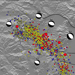
The main event was located at 8km shallow focal depth and it was followed by a rich aftershock activity, with five events of magnitude between 5Mw and 6Mw. The two strongest aftershocks took place: the first with magnitude 6.0Mw, on March 4, 2021 at 06:38 UTC, with epicenter at about 10km north of the main event and the second with magnitude 5.6Mw, on March 12, 2021 at 12:57 UTC, with epicenter at about 20km north-northwest, respectively.
The earthquake sequence revealed a buried NE dipping normal fault with a NW-SE strike, almost parallel to the main well known, mapped and studied Tirnavos – Larissa fault zone, seen some kilometers to the SE of the new event. The epicentral zone reveals that the active fault is buried under the mountainous area of Zarkos, west of Damasi.
A USGS ShakeMap computed at NOA shows a maximum MMI Intensity VII+ in the epicentral area. A maximum PGA of approximately 200cm/sec2 can be estimated were the main damages on URM buildings has been observed. Buildings in the rural area mostly of URM type and those that have not followed any EBC were severely damaged or collapsed. More than 1500 buildings were classed as uninhabitable, after the first and second investigation rounds. People have been moved to nearby available hotels and newly assigned camps of tents and containers, according to their needs.
Spectacular features of liquefaction were formed in the valley of alluvial deposits to the west and south of the epicentral area. Secondary phenomena were also observed, mainly surface cracks and failures of gravitational origin following the NW-SE strike direction. InSAR and GNSS data reveal also the main area of subsidence of the western part of the main fault, thus, justifying further the existence of the buried active fault.
Portable seismic networks have strengthened the monitoring in an area, recording in a greater detail the ongoing aftershock sequence and collecting important data for future research investigations.

  • Seismicity map of the aftershock sequence: Inlet marks the area, colour scale for date of the month, MTs for the events with magnitude Mw>5.0.

  • NOA computed USGS ShakeMap of the main event showing MMI intensity zoning (left) and max PGA contours (right).

  • Photos courtesy of local newspapers showing damaged dwellings in Damasi.

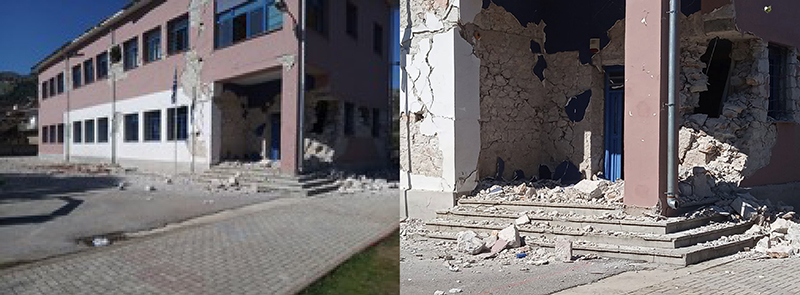
  • Photos courtesy of local newspapers. The school in Damasi damaged after the main event on March 3, 2021. All children and teachers managed to evacuate unharmed, following instructions after numerous exercises and specialized seminars on preparedness and awareness by the Earthquake Planning and Protection Organization. On the right the entrance/exit of the classes for evacuation.

Logo TURNkey shape

Intense seismic activity lead to a volcanic eruption in the valley of Geldingadalir (Iceland)

A small volcanic eruption started in Geldingadalir valley in Fagradalsfjall mountain, about 25 km SW of Reykjavík capital region, on Friday night 19 March 2021. The eruption was preceded by 3 weeks of intense earthquake activity and tectonic rifting episode, associated with a dike injection. The earthquake activity started on February 24, when a Mw5.7 earthquake took place in the same area. The new TURNkey network deployed in the region (see figure 1) recorded about 2500 earthquakes larger than Mw during this sequence. The 24 hours before the eruption, the rifting and seismicity died almost completely down. Once the eruption started, there was a persistent tremor at 2-4 Hz on the closest seismic station, but very low seismicity. As a result, very few events have since then been measured on the vertical seismometers of the TURNkey urban array in the town of Grindavík. However, the network monitors in real time seismic ground motion in the towns, and on rural stations.
The eruption (live feed here) (figure 2) is an effusive type on a short extensional fissure that now has concentrated into two main craters that are gradually being built up by tephra, and periodically collapse with lava floods flowing out onto the new lava field. The eruption is taking place in a small enclosed valley, and if it continues a large lava pool may be formed. The eruption is being fed from a deep rooted source within the mantle, most likely via a 1 m wide dike, that is about 3 km tall and a few km long according to modeling by deformation experts, and could potentially be long-lasting.
Well prepared hikers can even get close to the volcano and watch this phenomenon up close (see figure 2). The dispersion of the volcanic gases with the wind are being monitored and forecasted by the Vedurstofan Icelandic Meteorological Office, and while the levels appear to be mild, as this type of eruption usually is less gaseous than others, hikers are instructed to approach and stay upwind from the eruption, and away from depressions where poisonous gases may accumulate, in particular in low-wind conditions.
Testbed 3 (Iceland) of the TURNkey project is actively deploying additional stations in the area to monitor seismic ground motions in real time, producing data that are being used to develop and test the TURNkey platform.

1 Turnkey 25.3.2021
  • Figure 1. The TURNkey seismic network in southwest Iceland (triangles). The eruption location is illustrated by the schematic symbol of a volcano on left. The vertical geophone of the instrument monitors real-time earthquake ground motions and their progression across the network. Station color indicates the average noise level at the stations that varies with natural and man-made nearby disturbances.

2 Turnkey 25.3.2021
  • Figure 2. The main volcanic crater with orange lava flowing out of it, forming the most recent flow (light-gray) on top of its previous lava (black), with volcanic gases being emitted from the crater and the new lava field (blue). The eruption has been a big attraction with hundreds of people hiking every day to the volcano site. (Photo taken towards north, by Björn Oddsson).

Logo TURNkey shape

Earthquake Network rewarded in the AppsUP 2020 – Huawei HMS App Innovation Contest

Earthquake Network, the first operational smartphone-based EEW (Earthquake Early Warning) system, is among the winners of the 2020 global application innovation contest promoted by Huawei. Every year, the contest invites leading developers from around the world to submit smartphone apps which use the Huawei Mobile Services in order to help Huawei users navigate everyday life more easily.
More than 3,000 teams from over 170 countries and regions took part, with the contest receiving nearly 1,000 app submissions. This year, the apps submitted promoted innovation in areas such as education, agriculture, environmental protection, transportation and public safety.

Apps have been reviewed by an international panel of judges and voted by the public. Earthquake Network won a $15.000 prize in the “Most Socially Impactful App” category and has received the Honorable Mention by the panel of judges.
Huawei has also invited Earthquake Network to submit its app to the AppGallery store in order to increase its user base and improve its real time earthquake detection capabilities using smartphones which rely on the Huawei Mobile Services.
The collaboration with Huawei will help Earthquake Network to exploit the use of new devices for earthquake detection and for receiving the real time alert through multiple channels.

banner1
Logo TURNkey shape

Dynamic seismic risk communication and rapid situation assessment in face a destructive earthquake in Europe

Rémy Bossu, Istvan Bondàr, Maren Böse, Jean-Marc Cheny, Marina Corradini, Laure Fallou, Sylvain Julien-Laferrière, Frédéric Massin, Matthieu Landès, Julien Roch, Frédéric Roussel and Robert Stee – Euro-Mediterranean Seismological Centre (EMSC).

On December 29th 2020, a strong earthquake with a magnitude of 6.4 shook the city of Petrinja, 45 km south of the capital city of Zagreb. Eight people lost their lives. In March 2020, eight months before the Petrinja event, an earthquake with a magnitude 5.3 damaged the capital Zagreb to a similar extend. Due to the Zagreb earthquake and its aftershocks, the LastQuake app developed at the Euro-Mediterranean Seismological Centre (EMSC) had a high penetration rate of 7% in the country at the time of the Petrinja earthquake. In addition, EMSC had released a new website for mobile devices to optimise crowdsourcing of felt reports a few weeks before the Petrinja earthquake occurred. These specific circumstances made the Petrinja earthquake an ideal test case for dynamic risk communication and the rapid situation assessment tools developed by EMSC within the RISE and TURNkey projects. RISE (Real-time earthquake rIsk reduction for a reSilient Europe) is a project funded under the same H2020 call of TURNkey. Both projects aim at reducing future human and economic losses caused by earthquakes in Europe.
The Petrinja mainshock was detected within 66 seconds through a surge of EMSC website traffic and 11 seconds later from concomitant LastQuake app openings. These crowdsourced detections initiated a so-called “Crowdseeded seismic Location” (CsLoc). It is a method that exploits the geographical information of crowdsourced detection to select the seismic stations likely to have recorded the earthquake. The method also uses the time information to identify observed arrival times likely associated with this earthquake to perform fast and reliable seismic location. The automatic CsLoc was published 98 seconds after the earthquake and it was located 8 km away from the location that was manually reviewed afterward. EMSC received more than 2000 felt reports in the first 10 minutes, out of a total of more than 15000, before its servers started to experience significant delays due to the high traffic. These initial felt reports were sufficient to evaluate the epicentral intensity at VIII (for a final epicentral intensity of IX), i.e. damaging levels. Furthermore, they confirmed the heads-up from the automatic impact assessment tools “EQIA” (Earthquake Qualitative Impact Assessment). About 140 geo-located pictures were crowdsourced showing the effects of the earthquake. EMSC shared all the information on rapid situation assessment with the ARISTOTLE (All Risk Integrated System Towards Trans-boundary holistic Early-warning) group in charge of preparing an impact assessment for the European Civil Protection Unit within 3 hours of the event.

  • Automatic clustering of individual felt reports collected for the Petrinja (Croatia) earthquake in 10 km grid cells.
    Only cells containing a minimum of 3 reports are represented through their average intensity value.

A posteriori determined rupture orientation and position from felt reports collected within the first 25 min using the FinDer software developed at ETH Zurich are in good agreement with fault orientation from tectonic settings and aftershock distribution. This approach will be tested further in operational conditions in the coming months.
The large volume of collected felt reports accelerated the cooperation with the United States Geological Survey (USGS) to integrate them in USGS global ShakeMaps and define common geographical clustering approaches of individual reports.
Beyond these scientific results, a significant effort was devoted to complete automatic information published on Twitter @LastQuake by answering questions and explaining the reasons for service disruptions observed after several main aftershocks occurred. All communication was performed in English. We retweeted many of the tweets from the Croatian seismological institute and referred to them as much as possible. Questions followed according to the time evolution already observed after other damaging earthquakes. First, people were interested in the expected impact, then in the possible evolution of the seismicity, in the earthquake prediction (with the traditional confusion between forecast and early warning), and finally whether human activities (in this case hydrocarbon exploitation) could have caused the tremblors. During this period which lasted about two weeks, there were also many questions about seismology, such as the meaning of the magnitude, intensity, or the reasons for magnitude discrepancies between institutes.
It is difficult to evaluate the impact of this direct public communication effort quantitatively. Due to the English, in fact, only part of the population was reached. However, there are elements that seem to indicate that Twitter users appreciated our effort. The number of tweets viewed reached 9 million the day of the mainshock, and an average of 4.8 million over the first seven days. Again, this demonstrated the strong interest of the public in receiving information after a damaging earthquake and during an aftershock sequence. Tweets explaining that earthquake prediction does not exist were liked 700 times. Many users reported that getting rapid information and direct answers to their questions was the key to decrease their anxiety. This public interest led to tens of interviews in national and regional media. But perhaps more meaningful in terms of public appreciation, EMSC collected more than 2000€ from individual donations and received many offers for technical support in relation to our service disruptions from both IT specialists and companies. This experience also underlined the many improvements that still need to be done, from strengthening our IT infrastructure to hierarchize information during an aftershock sequence better. In general, the great interest shown by the public in Croatia in receiving information after the Petrinja event demonstrates a strong need for dynamic risk communication. Moreover, it proves that crowdsourcing can significantly improve the capacity for rapid impact assessment.

Logo TURNkey shape

Multi-sensor instrument deployments in selected seismic regions of Europe underway in the TURNkey project

A total of 132 TURNkey RS4D accelerometric and seismic sensor units and 26 TURNkey GNSS units are being deployed in six European Testbeds (TBs): TB1: Bucharest, Romania; TB2: Pyrenees, France; TB3: Towns of Hveragerði and Húsavík (Iceland); TB4: City of Patras and Aegion, Greece; TB5: Ports of Gioia Tauro, Italy; and TB6: Groningen, Netherlands. The deployments serve the purpose of partially addressing weaknesses in existing sensor networks, and to secure and demonstrate the real-time streaming of multidisciplinary data (e.g., seismic, deformation, structural response, etc.) that adhere to a common data format and are recorded by multisensor instruments in European seismic regions that range in their tectonic setting, levels, and types of earthquake hazard, population densities, types of vulnerable infrastructure, and spatial extents. This data, in addition to earthquake impact reports from worldwide affected seismic regions (TB7), and transient data from TURNkey’s EEW mobile system for aftershock (TB8), forms the basis of the development of the anticipated TURNkey platform. The deployment now stands at 60% completeness, with two TBs having completed their installations of RS4D and collocated GNSS units at M18-M20. The deployment status has thus reached a level that fully enables the testing of solutions developed and their validation, which is the focus of the first part of the second half of the project. Then, the platform is to be evaluated by stakeholders in the TBs, with respect to its performance in forecasting, early warning, consequence prediction, and response to strong earthquake occurrence and effects.

  • TURNkey seismic sensor installed within a building in Bucharest, Romania (TB1).

  • A GNSS station inNorth Iceland, just outside the town of Húsavík (TB3), with a TURNkey RS4D enclosed in a IP67 weather-proof box anchored to the bedrock and under a protection cover.

  • A standalone TURNkey RS4D unit in Húsavík (TB3) under a protection cover on the floor of a building basement. The unit is composed of a power-over-ethernet cable connecting the RS4D with a connection box on the wall containing mains voltage transformer, backup battery, and a 4G low-frequency router.

  • TURNkey multi-sensor unit, including a seismic sensor and a GNSS receiver, deployed on a strategic wharf structure at the port of Gioia Tauro in Italy (TB5).

Logo TURNkey shape

Presentation of TURNkey Project at the Gioia Tauro port, one of the European testbeds of the project

On Tuesday December 17, 2019 at 9:00 a workshop will be held at the Port Authority of Gioia Tauro for the presentation of the TURNkey project (Towards more Earthquake-resilient Urban Societies through a Multi-sensor-based Information System enabling Earthquake Forecasting, Early Warning and Rapid Response actions; funded by the European Union research and innovation program H2020; the project lasts three years and started on June 1, 2019. Within the project, six case studies (testbeds) located in Europe were selected; one of the testbeds is the port of Gioia Tauro. The event will be attended by the staff of the European Center for Training and Research in Earthquake Engineering, EUCENTRE, project partner and coordinator of the activities related to the case study of the port of Gioia Tauro, together with the TURNkey project stakeholders in Italy; in particular, in addition to the staff of the Port Authority of Gioia Tauro, the hosting institution, the institutional bodies, including local administrations and the Civil Protection, will participate to the workshop. The presence at the port of Gioia Tauro of the Infrastructure and Transport Ministry of the Italian Government has been announced for Tuesday December 17, 2019.

Logo TURNkey shape

University of Alicante and TURNkey project

On July 17, the University of Alicante and the local newspaper “Información” published two articles that briefly describe the TURNkey project and its objectives. Besides, both news define the role that the University of Alicante will play in the project.
The abovementioned news are in spanish and are available at the following links:
• Universidad de Alicante => La UA participa en el desarrollo de un sistema de información sísmica que permitirá gestionar emergencias en tiempo real
• Información => La UA desarolla un sistema de información sísmica para gestionar emergencias en tiempo real

Logo TURNkey shape